
GIS K100
- Ref Price:
-

- Loading Port:
- China Main Port
- Payment Terms:
- TT OR LC
- Min Order Qty:
- -
- Supply Capability:
- -
OKorder Service Pledge
OKorder Financial Service
You Might Also Like


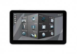


PJK-100 is based on WINDOWS MOBILE6.5 operating system, and it has high-resolution 3.5-inch 480X320 pixel touch screen, with wireless LAN and WAN 2.75G Netcom Communications and data transfer, support for GPS, 320 million auto-focus camera and video, support one, two dimensional scanning laser or image reading, support 13.56Mhz RFID reader, Bluetooth 2.0 short distance data transmission.
PJK-100 is an ideal, cost-performance ratio mobile GIS mapping solutions, in addition to the application of highly integrated functions, it is in strict accordance with industry standard IP54 package designed to meet the concrete floor 1.2 m drop test. And is equipped with a safety 3400mAh lithium polymer battery, to meet the equipment at full capacity 12 hours work!
1, the overall requirements
* 480x320 touch screen, 320 million camera, GPS
* Support for a two-dimensional scanning laser or image reading
* Support wifi, wide area network, RFID, Bluetooth, USB transfer
* 12 hours of continuous work, 30 days standby
2, the physical parameters
* Size: 155 mm (length) x 70 mm (W) x 26mm (thick)
* Weight (with standard battery): Standard battery, 265 g
* Display: 3.5 inch, HVGA (480X320) TFT high-brightness, touch screen
* Touch Panel: Glass analog resistive touch screen
* Backlight: LED backlight
* Main battery: 3.7V 3400mAH Li-polymer rechargeable battery smart
* Battery performance: full load of work for 12 hours, 300 hours standby
* Expansion Slots: Mini SD cards up to 32G
* Tip: Vibrating alert / LED prompts / Audio Tips
* Keyboard: side button + power button + the front of 30 keys keyboard
* Audio: Built-in microphone / MiniUSB headphone connector
3, the working environment
* Operating temperature: -30 ℃ ~ 50 ℃
* Storage temperature: -40 ℃ ~ 60 ℃
* Humidity: 5 ~ 95% (no condensation)
* Drop Specifications: multiple 1.2m (4ft.) a drop of cement concrete floor
* Seal standard: IP54
* Electrostatic Discharge: + /-15kV air discharge, + /-8kV direct discharge
4, the performance parameters
* CPU: ARM architecture Hisilicon 520MHZ
* Operating System: Microsoft Windows Mobile 6.5 Professional
* Memory: 256MB Flash ROM + 128MB SDRAM
* Interface: Mini USB interface / charge cradle
* Bluetooth: Bluetooth 2.0 + EDR
5, the network connection
* Wireless voice communication: 900/1800MHZ GSM
* Wireless Wide Area Networks: GPRS / EDGE
* Wireless LAN: WI-FI 802.11b / g
* GPS: with AGPS function Srif Star III navigation chip
* Camera: 320 mega pixel auto focus with LED fill light
6, data collection specifications
* Bar code: one-dimensional laser imaging, two-dimensional image scanner
* RFID 13.56MHZ, compatible with 14443/15693 protocol
7, one-dimensional laser scanner
* Optical resolution: greater than or equal 4mil
* Scan Depth: 3.81 cm -60.98 cm
* Scan angle: 47 ° ± 3 ° (standard)
* Scan speed: 102 ± 12 times per second (bi)
8, two graphics scanner
* Optical resolution: greater than or equal 3mil
* Scan angle: all the
* Scan speed: 300 times
9, GPS parameters
* 12-channel, L1 frequency C / A code, 1Hz update frequency; first fix time of 30 seconds (typical)
* 1 ~ 3 m accuracy in real time or post-processing, support for WAAS, EGNOS, MSAS wide area differential systems
* NMEA-0183 and SiRF protocol
10, optional software
PJK-100 is based on Microsoft Windows Mobile 6.5 operating system, provides an open platform to support third-party software, As a leader in the field of GIS, it can enable users to install third-party GIS software. Such as ESRI's ArcPad software.
Key Features:
Real- time meter accuracy
Integrated communications
Long life battry for professional
cost-effective mobile GIS mapping solutions
IGS-100 is based on Windows mobile 6.5 operating system, and it has high-resolution 3.5-inch 480X320 pixel touch screen, with wireless LAN and WAN 2.75G Netcom Communications and data transfer, support for GPS, 320 million auto-focus camera and video, support one, two dimensional scanning laser or image reading, support 13.56Mhz RFID reader, Bluetooth 2.0 short distance data transmission.
IGS-100 is an ideal, cost-effective mobile GIS mapping solutions, in addition to the application of highly integrated functions, it is in strict accordance with industry standard IP54 package designed to meet the concrete floor 1.2 m drop test. And is equipped with a safety 3400mAh lithium polymer battery, to meet the equipment at full capacity 12 hours work!
- Q:GPS handheld function to measure it?
- It depends on what kind of GPS handset. Some machines have this feature.
- Q:Handheld GPS need to put the phone card?
- Travel GPS professional solutions:Put card. Will be equipped with a card at the time of purchase.
- Q:How do I still stay in the GPS navigation, GPS monitoring of the primary idea? FiveBusiness services, thank you!Future business services
- 1 power, telecommunications, telecommunications and other network time synchronization2 accurate timing of admission3 accurate frequency of admission1 geodetic measurements of various levels2 Road and various line lofting3 underwater topographic survey4 crustal deformation measurement, dam and large building deformation monitoring5.GIS application6 construction machinery (tyre crane, bulldozer, etc.) control7 precision agricultureAt the present stage, it is mainly used for the security of vehicles and the management of personnel vehicles. With the continuous development of social economy, more and more vehicle users, GPS will gradually get wide application, on the stage of the car is enough for your service. Prospects can still be Lin Shijie GPS
- Q:I just bought a handheld GPS Magellan No. 1, showing the latitude and longitude coordinates, I want to set the geodetic coordinates of latitude and longitude, do not know where to set, I would like to ask you, how to set, there is a better picture shows the best, thank you so much.Magellan GPS 210 is not 2000 shy
- 1 position: [format setting unit - "[] position display format is set to User UTM Grid, and enter the relevant parameters, such as the 3 degree or 6 degree with the area with the central meridian projection, the ratio was 1, that deviation is 500000m, north-south deviation is 0.2 map reference setting: [[map] - unit "benchmark is set to User, and input the DX, DY, DZ, DA, DF parameters, usually DX, DY, DZ vary from region to region, so need to know the high level control points to solve, solving methods are as follows:The handheld GPS is placed in the control point field buried pile, were measured, and then hand coordinate coordinates and the known control points of the GPS measurements obtained for the poor, can be obtained by local coordinates and elevation deviation value: DX, DY, DZ.
- Q:How the German born handheld GPS Mu meter, I want to buy?
- The data acquisition function of scientific, simple and accurate measurement of area, display area and the "Mu", "price" area can be set automatically calculate the area of "price", fit the actual demand Chinese industry users on the data collection and usage, highlighting the professional quality.Is the highest cost-effective mid-range machine
- Q:I am ready to go to the field to go to college, but I do not know how to buy a handheld GPS, I hope you recommend. The most important thing is easy to carry.
- Is not a professional geography or geological personnel, there is no need to use Garmin ah Magellan what ah, you do not need. Using a mobile phone that can accept GPS signals is enough, free software and maps can be found on the internet. On the market a lot of 2000 yuan or so of the phone has this feature, remember that the phone has GPS signal acceptance, not GPRS oh!
- Q:How about the accuracy of the GPS handset?
- So the selection depends on your needs the function and budget. Haida official website mall "mobile MGIS mall".
- Q:Hand held GPS coordinate conversion method
- Three parameter test DX, DY, DZ, DA, DF after the conversion parameters of the five, must be prompted to enter the handheld GPS, while the input area of the central meridian longitude. E on behalf of the east longitude, projection ratio of 1, the deviation of things to the north and south of the deviation of 0, and set the unit for M. Enter these parameters, should be taken to the field test, check whether these five parameters are correct. The method is selected, vision, GPS receiving signal strength of the feature points in the field (such as linear object intersections, independent features, etc.) is the best stone control points were measured and compared with theory and find out the coordinates of these points. If the results of the comparison exceed the nominal accuracy of the instrument, the conversion parameters or the problems that should be found should be recalculated.
- Q:Handheld GPS each brand has what difference; different price difference in where is the positioning accuracy is different or what function is not the same?What are the differences between the measurements and the cars?
- I was engaged in car GPS positioning, the first difference between different prices is the biggest cost of different module determines the price, this is the precise positioning of the key, but also the guarantee of product quality, rather than low-cost copycat version, as a kind of different price mobile phone, why Apple four generation sell so expensive but, only a few hundred to copycat.
- Q:Handheld GPS which brand is good
- Now GPS can also do handheld measurement accuracy, precision can usually reach decimeter level, the industry there are relatively well-known Huace, professional GPS measurement instrument, high precision of handheld GPS the good.
1. Manufacturer Overview |
|
|---|---|
| Location | |
| Year Established | |
| Annual Output Value | |
| Main Markets | |
| Company Certifications | |
2. Manufacturer Certificates |
|
|---|---|
| a) Certification Name | |
| Range | |
| Reference | |
| Validity Period | |
3. Manufacturer Capability |
|
|---|---|
| a)Trade Capacity | |
| Nearest Port | |
| Export Percentage | |
| No.of Employees in Trade Department | |
| Language Spoken: | |
| b)Factory Information | |
| Factory Size: | |
| No. of Production Lines | |
| Contract Manufacturing | |
| Product Price Range | |
Send your message to us
GIS K100
- Ref Price:
-
- Loading Port:
- China Main Port
- Payment Terms:
- TT OR LC
- Min Order Qty:
- -
- Supply Capability:
- -
OKorder Service Pledge
OKorder Financial Service
Similar products


New products

Hot products


Related keywords

