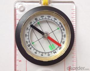
Map Direction Compass DC35-1A
- Loading Port:
- China Main Port
- Payment Terms:
- TT OR LC
- Min Order Qty:
- -
- Supply Capability:
- -
OKorder Service Pledge
OKorder Financial Service
You Might Also Like
Model: DC35-1A
Name: Professional map compass, ruler compass
Product Origin: China
Supply Ability: 10,000 pcs/month
Minimum Order: 30 pcs
MOQ for OEM package: 500pcs
Material: Plastic
Features
1, professional usage: orientation, distance measuring, measuring slope, azimuth and pitching Angle measurement, drawing, a magnifying glass
2, high quality compass with neck rope, portable and rugged
3, ACRYLIC material, about 2mm thick
4, Damping Dial: to keep the stability of the pointer, more suitable for outdoor
environment.
5, Accuracy: accurate and clear, there were 360 degrees azimuth Angle, outer ring is 64-00 system, Liquid filled in the compass for reliable readings.
6, Magnifier function
- Q:How to set the handheld GPS related parameters and coordinate conversion parameters throughout the country
- Two. To coordinate the coordinate data of the control points obtained provide technical support unit of Beijing Unistrong companies around the branch responsible person to calculate the coordinate transformation parameters conversion parameters, or to obtain their own conversion conversion software. After the conversion parameters are calculated by the prompt input handheld GPS. Only after such a setup, after all the soil in the region when the coordinates of the GPS read out the coordinates of the point for the Beijing 54 coordinates.
- Q:I am a handheld GPS precision is low, how to use to be able to improve certain accuracy
- If you can join the CORS network, the accuracy of decimeter to centimeter level.
- Q:Handheld GPS positioning, can be directly uploaded to the computer, and the computer has a scalable map to mark the upload point. The above system, now there are 20Such as the title, I want to achieve the final function: through the manual to a point, with a hand-held GPS locator will be recorded in the specific latitude and longitude, and sent to the network in real time, for my computer to mark these points on the map. If you can directly enter the site of some of the information, directly to the above is the bestIf you have the above equipment, please indicate the scientific name, and the specific application industry.Thanks.
- 10 classification layer management, you can hide / show layer.11 support batch import export data.12 support for drawing straight lines, curves and any line segments, can change the color and width.
- Q:How to use the handheld GPS whole watershed investigation
- The critical value is an object from a physical state to another physical state, a physical quantity to meet the conditions, which is equivalent to the stagnation point in Mathematics
- Q:What is the difference between professional GPS handsets and mobile navigation?
- GPS is the most important positioning accuracy. Professional handheld machine with industrial design. First of all, if used outdoors, then fell, and so on are likely to water, and this thing is also very expensive, so the opportunity to have a high professional anti shock waterproof performance.
- Q:Hand held GPS coordinate conversion method
- Three parameter test DX, DY, DZ, DA, DF after the conversion parameters of the five, must be prompted to enter the handheld GPS, while the input area of the central meridian longitude. E on behalf of the east longitude, projection ratio of 1, the deviation of things to the north and south of the deviation of 0, and set the unit for M. Enter these parameters, should be taken to the field test, check whether these five parameters are correct. The method is selected, vision, GPS receiving signal strength of the feature points in the field (such as linear object intersections, independent features, etc.) is the best stone control points were measured and compared with theory and find out the coordinates of these points. If the results of the comparison exceed the nominal accuracy of the instrument, the conversion parameters or the problems that should be found should be recalculated.
- Q:Highway measurement with GPS I do not know which of the base station settings and mobile station settings I are very vague, to the instrument to build a coordinate system how to build the relevant issues to me
- For long tunnels, the conventional measurement of large bridges has the following limitations:1, long tunnels, bridges and other structures generally require the measurement level of four or more. With conventional measurement methods, often adopt the measure to increase the number of methods to extend the observation time, time consumption and labor consumption to try to improve the accuracy of.2, the long tunnel and bridge for the complex terrain region difficult, conventional control measure for visibility and network shape, often cut down the workload is quite large, so the measurement of the cost of a large, hard work.Link control network of high precision 3, long tunnel and bridge and low precision and route network, although with adjustment methods can be overcome, but because of the terrain conditions are difficult, the measurement workload to its connection, and is not too easy. In practical work, the control of the structure and the measurement of the route are often out of touch.
- Q:Welcome to make comments on the existing GPS tour pal what shortcomings to answer the more detailed the better
- Fifth elements: the terrain map is the main project of outdoor sports climbing, mountain climbing is very exhausting, we usually do a plan will be completed on schedule, a good plan should be to our destination in the manual run out before. And if you want to do this, it must be on the road difficult to have a correct anticipation. But this time, with the terrain map GPS can come in handy, the mountains and the altitude of the understanding, we need to know about these sections spend much time and energy. And the general GPS map, is unable to meet the needs. So we'd better buy a map with contour terrain data of professional grade GPS, make your own outdoor journey do in our hands.
- Q:Verify the accuracy of the GPS device to buy back, the way is to use Android under the'gps state 'software, to test the accuracy of real-time single point positioning.1 with two sets of the same Android Tablet Computer (custom machine, type of bad) in the same position for receiving, find that the accuracy is the same (software, are 1-2 meters), but the position would be poor 10 meters or more. It's in the same place.The 2 one is the Android tablet computer, a mobile phone is HTC G10, also received together in the same position, find that the accuracy is not the same as (the latter 20 meters or so), but also may be about 10 meters position difference.The accuracy of this GPS device can reach 1-2 meters, while the same location in real-time single point positioning error of 10 meters, a reasonable explanation.
- You are very normal, the tablet computer and mobile phone antenna, not inside, the highest accuracy is about 10 meters, as ordinary navigation is good enough, to achieve centimeter level accuracy by GPS single is, that is to achieve the RTK measurement, is the application of professional measurement, now RTK or by the United States GPS satellite, not the United States GPS satellite as China Beidou mobile station and the base station is in need of mutual difference calculation to achieve accurate measurement. Now the single can receive SBAS signal, single precision up to 1-2 meters, the Northeast in some places to achieve sub meter level, which is the highest single precision can reach, is also used in field investigation using professional machine.
- Q:Seeking the similarities and differences between RTK and GPS
- RTK full name is GPS-RTK real-time dynamic distribution, which you know.
1. Manufacturer Overview |
|
|---|---|
| Location | |
| Year Established | |
| Annual Output Value | |
| Main Markets | |
| Company Certifications | |
2. Manufacturer Certificates |
|
|---|---|
| a) Certification Name | |
| Range | |
| Reference | |
| Validity Period | |
3. Manufacturer Capability |
|
|---|---|
| a)Trade Capacity | |
| Nearest Port | |
| Export Percentage | |
| No.of Employees in Trade Department | |
| Language Spoken: | |
| b)Factory Information | |
| Factory Size: | |
| No. of Production Lines | |
| Contract Manufacturing | |
| Product Price Range | |
Send your message to us
Map Direction Compass DC35-1A
- Loading Port:
- China Main Port
- Payment Terms:
- TT OR LC
- Min Order Qty:
- -
- Supply Capability:
- -
OKorder Service Pledge
OKorder Financial Service
Similar products
New products
Hot products
Hot Searches


