
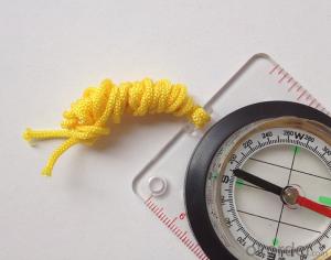

Good Mapor Ruler Mini-Compass DC45 for Surveying
- Ref Price:
-

- Loading Port:
- Tianjin
- Payment Terms:
- TT OR LC
- Min Order Qty:
- 20 pc
- Supply Capability:
- 10000 pc/month
OKorder Service Pledge
OKorder Financial Service
You Might Also Like


Model: DC45-5A
Name: Professional map compass, ruler compass
Product Origin: China
Supply Ability: 10,000 pcs/month
Minimum Order: 20 pcs
MOQ for OEM package: 500pcs
Product Size: 108*61*16 (mm)
Features of DC45-5A
1, professional usage: orientation, distance measuring, measuring slope, azimuth and pitching Angle measurement, drawing, a magnifying glass
2, high quality compass with neck rope, portable and rugged
3, ACRYLIC material, about 2mm thick
4, Damping Dial: to keep the stability of the pointer, more suitable for outdoor environment.
5, Accuracy: accurate and clear, there were 360 degrees azimuth Angle, outer ring is 64-00 system, Liquid filled in the compass for reliable readings.
6, Magnifier function
5,ruler compass,
6,for map measure and drawing
7,one meter neck rope,
8,Liquid filled in the compass for reliable readings,
9, magnifier function.
- Q:GPS handheld function to measure it?
- Depends on the accuracy of the range you require, if the accuracy of the 3-5 meter can be used for ranging, measuring area, latitude and longitude, elevation information, etc.
- Q:I would like to ask the GPS handset and GPS receiver (Surveying and mapping qualification application needs) is there a difference? If yes, what is the difference?
- GPS handheld GPS operating manual, GPS receiver is to receive satellite signals, GPS consists of two components.
- Q:What is the difference between industrial GPS handset and mobile navigation
- 5, strong battery life, is a major feature of professional GPS, Garmin handset General of dry batteries can be used more than ten hours, while the mobile phone GPS on GPS also can use a few hours, if you open the GPS in general about 3 hours will be over.6, supporting different software. Professional GPS handheld opportunities related to the PC end of the data processing software, this software can achieve the acquisition of data processing, as well as the application of data collection. The phone GPS can only navigation, and navigation is only a small part of the GPS function.I simply say these, this is my personal summary of the difference, if you have what is not clear can exchange. Want to help you.
- Q:Professional handheld GPS GARMIN (DR) how to use
- Would like to use the function of handheld GPS purposes, the measurement of soil area, linear navigation, auxiliary fishing waypoint navigation point information, traffic data display, etc.
- Q:The navigation module it is "selph" three generation? Another one I mainly use it to measure the land area, easy to use, the error is not big?I want to buy Magellan 500 do not know whether it is good to use
- A type specific.GPS chip area measurement is the most "selph" 3 generation, special machine is very good, the error is very small.
- Q:Ask how to select a google satellite map into a handheld Area GPS
- The ordinary mobile phone GPS, can install Orville interactive map support pre download any regional satellite map, support for offline use
- Q:How to hand GPS eTrex H data to the computer
- "Shaanxi skmax navigation information Limited" GARMIN proxy (GARMIN official website can be found), contact (Xiao Hou) the hope can help to you, if you do not understand what we see on the Internet, may at any time, contact us!
- Q:Mountaineering to buy a professional GPS or Mountaineering Watch
- Can be downloaded in general maps, satellite maps, and even contour maps, which features far more than handheld GPS or mountain climbing watches, you can better meet the needs of mountaineering.
- Q:Seeking the similarities and differences between RTK and GPS
- GPS: is the satellite positioning system in general, narrow sense refers to the GPS satellite, and the narrow sense refers to all can receive GPS signal equipment; RTK refers to the dynamic real time difference measurement, it also refers to the difference can be used for real-time dynamic measurement equipment. The difference between the two measurements from speaking: GPS contains RTK, also includes some precision lower grade equipment, such as the Garmin handset, handset, GPS meter level navigation etc..
- Q:Handheld GPS brand rankings
- SIBAOIn the GNSS coordinate precision and attributes, "SIBAO" has a professional GPS handset, GIS i-PPP GIS, a mobile data collector, GIS, high precision GIS, high precision measurement of RTK complete product structure, to form a comprehensive solution to the spatial information industry scheme. Set of SIBAO products awarded the Beijing independent innovation product identification certificate, satellite navigation and Engineering Excellence Award and other professional awards. At the time, location, navigation and other comprehensive applications, Unistrong successful implementation of hundreds of large projects, services in many national key projects, won the national honor.MagellanGarmin
1. Manufacturer Overview |
|
|---|---|
| Location | |
| Year Established | |
| Annual Output Value | |
| Main Markets | |
| Company Certifications | |
2. Manufacturer Certificates |
|
|---|---|
| a) Certification Name | |
| Range | |
| Reference | |
| Validity Period | |
3. Manufacturer Capability |
|
|---|---|
| a)Trade Capacity | |
| Nearest Port | |
| Export Percentage | |
| No.of Employees in Trade Department | |
| Language Spoken: | |
| b)Factory Information | |
| Factory Size: | |
| No. of Production Lines | |
| Contract Manufacturing | |
| Product Price Range | |
Send your message to us
Good Mapor Ruler Mini-Compass DC45 for Surveying
- Ref Price:
-
- Loading Port:
- Tianjin
- Payment Terms:
- TT OR LC
- Min Order Qty:
- 20 pc
- Supply Capability:
- 10000 pc/month
OKorder Service Pledge
OKorder Financial Service
Similar products


New products
Hot products


Hot Searches

